AC Canyon Trail Hiking & Biking Route
AC Canyon is a trail that takes you from the end of the Suncoaster Trail where it heads over to McKay Rd. to Menacher Rd. and onto the Suncoaster Trail again. In other words, you don't have to exit the Suncoaster Trail at McKay Rd. and Hwy. 101 and ride the highway to Menacher Rd.
The only reason the SCRD did not take the Suncoaster Trail this route is because the crossing over Anderson Creek is not suitable for ATV traffic as it is too narrow and the Suncoaster Trail is supposed to be multi-use including ATVs. The route is however, more than adequate for hikers and mountain bikers.
I will describe the route and give directions coming from Menacher Rd. over to the Suncoaster Trail at Hallowell Forest Service Road.
If you are coming from Earl's Cove you will simply need to follow the directions from bottom to top. Just remember when you get to Menacher Rd. you will turn left to follow the Suncoaster Trail. Otherwise you will end up back down at the highway and have to turn around and come all the way back up the hill.
 Same map using Mapsource.
1. Approximately 3.2 kms past the Madeira Park Rd. turn right onto Menacher Rd.
2. Travel approx. .8 kms to the second Trail Rides sign (don't take the road at the first sign.
3. You can either park here if you have a vehicle that can't travel a rough logging road and walk or you can turn left onto this logging road and travel .9 kms to the junction where a dirt road heads off to the left off the main logging road. I managed to drive up to this point with my car and parked here(usually I park at the bottom and walk up).
4. Take this dirt road and travel along for 15 or 20 minutes (if you are walking) until you come to a trail off to the left. It is marked with a sign "AC Canyon".
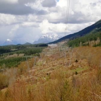
5. This trail will take you over to the big powerlines. Follow the trail under the lines and cross over the powerline road and straight back into the trail which is a continuation of AC Canyon trail.

This is a view down the powerline and the road you will be following.
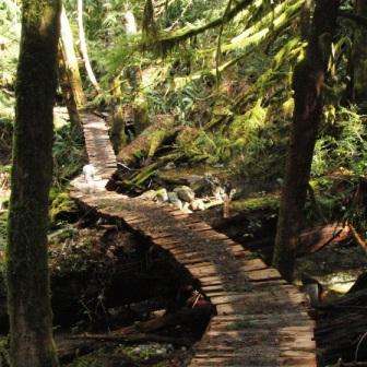
6. The trail will take you down to Anderson Creek, switchbacking down to the bridge. Over the bridge and then back up and out to the powerlines again
 Bridge over Anderson Creek.
7. Turn right and follow the powerline road all the way down. You'll see an old grassy road and right after a trail, both off to the left. Keep to the powerline road and you will come to a gate made of two logs. I crawled under it and continued on to the right.
8. Follow this road until it comes out onto a forest service road (it's Hallowell Forest Service Rd.) that goes off to the right and more or less straight ahead. You want to keep going straight (don't turn right).
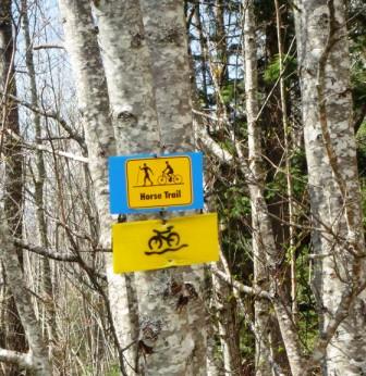
9. A little further along you'll come to a trail off to the left called "Horse Trail". This trail will cut off the forest service road and take you down to intersect with the Suncoaster Trail.

10. You'll come into a clearing with a picnic table. Go ahead just past it and if you go to the left you'll come out at the end of Sunview Rd. which you can follow to McKay Rd. and then down to the highway. If you wanted you could ride back to your vehicle at Menacher Rd. via the highway.
11. Or you can go right back out to the forest service road and turn right. A short distance up the road you'll see the Suncoaster Trail continue on the left. If you have the time, you could continue towards Earl's Cove on the Suncoaster.
12. Otherwise continue past the trail on the road and you'll pass the entrance to Horse Trail again on your right. Follow the road back to AC Canyon and back to your car.
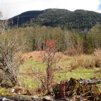
 Mt. Hallowell in the background.
Click here to return from AC Canyon to the Bikes & Hikes page.
Click here to return from AC Canyon to the Sunshine Coast Trails Home page.
New! Comments
I began this site as a labour of love and in response to what I believed was a need to have one comprehensive website with detailed information about all trails on the Sunshine Coast.So here it is several months later and I've had so much fun hiking, biking and gpsing nearly every trail on the Sunshine Coast. Along the way the site has gained some loyal followers and we would love to know your thoughts about this page, site and/or the Sunshine Coast...
So if you have a moment (and a Facebook account OR Yahoo, AOL, Hotmail) please leave a comment in the box below.