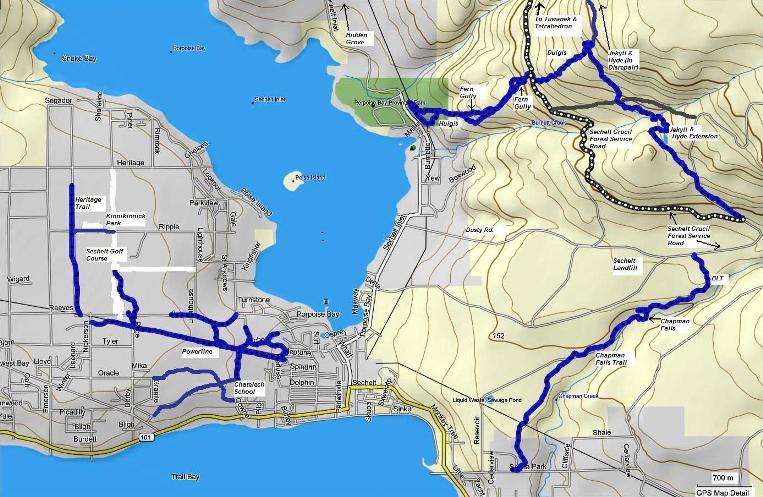
Sechelt Trails Map
The town of Sechelt is nestled on a narrow isthmus of land with the Strait of Georgia on one side and Sechelt Inlet on the other. The name Sechelt actually means "land between two waters" and was named after the shishalh who are the original First Nations people of the region.
To access the area, travel northwest on Hwy. 101 (Sunshine Coast Highway) from Gibsons approximately 23 kms. I've included the Porpoise Bay, Sandy Hook, and Tuwanek areas into the Sechelt general area.
Many of the trails that follow along the powerline or connect to the
powerline access road have no names. These trails are generally
appropriate for both hikers and bikers. Other than the Heritage Trail
which is easy, I would rate these trails as intermediate. There is some
blow down and minor obstacles on some of the trails as well.
I will be adding a page for Kinnikinnick Park and trails in the near future.
Click on a trail in the map below to see details
Click here to open pdf version of this map with higher resolution.

Click here to return from Sechelt Trails map to Sechelt trails.
Click here to return from the Sechelt trails map to the Sunshine Coast Trails Home page.
New! Comments
I began this site as a labour of love and in response to what I believed was a need to have one comprehensive website with detailed information about all trails on the Sunshine Coast.So here it is several months later and I've had so much fun hiking, biking and gpsing nearly every trail on the Sunshine Coast. Along the way the site has gained some loyal followers and we would love to know your thoughts about this page, site and/or the Sunshine Coast...
So if you have a moment (and a Facebook account OR Yahoo, AOL, Hotmail) please leave a comment in the box below.