Carlson Lake Hiking and Biking Route
Carlson Lake is a very popular destination for fly fishermen and dirt bikers, atvs and 4X4s. Located off the Carlson Lake Forest Service Road, it is easily reached most times of the year. In winter I definitely wouldn't try going in without a 4X4 - 2-wheel drive won't cut it as there is usually a fair amount of snow at this elevation. In summer months if you go in from the north end of the lake, the road is pretty good, but I wouldn't take my car in. The south end is really rough with steep, rocky areas that to me look impossible even with 4-wheel drive.
It is also an easy hike in most of the year, but in winter expect snow. Mountain biking is also good, but the last .8 km in from the south is pretty much straight up a rough and rocky dirt road. I'd be walking my bike both up and down it. Access to the lake is via the Halfmoon Carlson Forest Service Road.
Over the last year the area along the Halfmoon Carlson FSR has been actively logged. I'm not sure as of May 2012 if they have finished in the area or not so use extreme caution on the road.

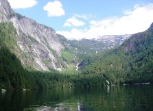
Carlson Lake in early spring. Still covered in about three feet of snow.
- Take the second Trout Lake Rd. turnoff from Hwy. 101. This is the one closest to the Halfmoon Bay store and government dock. It's about 10 kms from Sechelt.
- Follow Trout Lake Rd. to the intersection where Trout Lake Rd. veers right and the Halfmoon Carlson Forest Service Road heads straight up.
- Stay on this road, through the intersection of Branch 02 spur of the FSR. Do not turn right or left here, but go straight up the hill.
- The road gets a little bit rough between the 2 and 3 km marker, but I was able to take my little Nissan up. If in doubt, park and carry on by foot or bike.
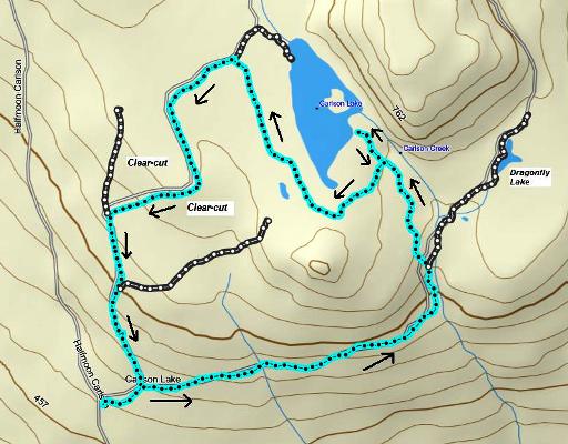
- The road forks off to the right between the 3 and 4 km marks and this is the road you want to take. This is also where I usually park my car. Distance from here into Carlson Lake is approx. 3.3 kms (6.6 kms return) and the circle route is about 8.5 kms.
- There has been a lot of logging going on up this road so be very careful of large logging trucks heading up and down.
- Go about .5 kms up this road and take the first road on the right. I am assuming you are either on foot or your bike. If in a vehicle then I would reverse this route to Carlson Lake and return the same way.
- You will cross a ditch when you enter this road and will cross two more gullies after a short distance.
- After about 2.5 kms you will come to a road that goes off and up on the left. Keep on this road for about .8 kms right to the lake.
- On your way up, maybe .3 kms or so from the lake you will see a road on your left. If you want to do the circle route this will be the road you take on the way out.
- If you just want to do an in and out, then follow the same route out as you did coming in. For the circle route, on the way back out from the lake turn right on this road and follow it until you come to a T intersection (2 or 3 kms).
- You will turn left here (right will take you up to the trail into the north end of the lake).

North end of Carlson Lake.
- Follow the road a short distance to the next T intersection (maybe a 5 minute walk) and turn left again. There is a marker up on a tree at this intersection marking 12 kms.
- As you follow this road down you will pass the 11.5 km marker and a sign warning you about active logging. You will come into the recently clear-cut area.
- Keep on until the next T intersection and then turn left. Follow this road back down to where you parked your car (about 1 km).

Click on the map above to open a larger pdf version.
The route (in green) viewed in Google Earth.
Click here to return from the Carlson Lake route to the Hikes and Bikes page.
Click here to return to the Sunshine Coast Trails Home page.
Enjoy this page? Would you like to link to it? Here's how:
Would you prefer to share this page with others by linking to it?
- Click on the HTML link code below.
- Copy and paste it, adding a note of your own, into your blog, a Web page, forums, a blog comment,
your Facebook account, or anywhere that someone would find this page valuable.
|


