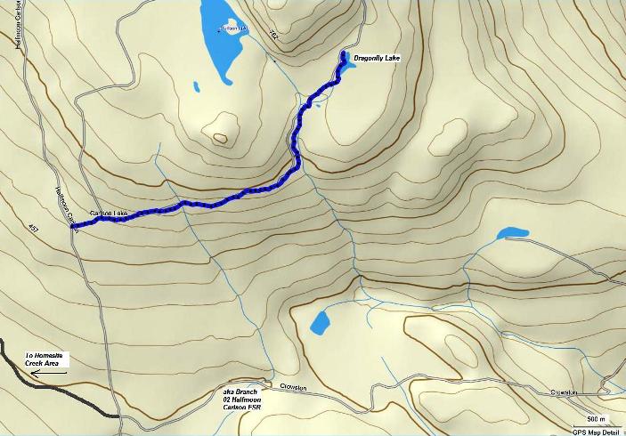
Dragonfly Lake Hiking & Biking Route
Dragonfly Lake is a tiny lake just a little southeast of Carlson Lake in the Halfmoon Bay area. It is along a rough dirt track that is named Carlson Lake Rd.
The route in is quite lovely and makes an easy bike or hike in that will likely take you an hour or two return, depending on where you decide to start from. Access to the lake is via the Halfmoon Carlson Forest Service Road. As of summer 2011 there is active logging in the area so use extreme caution on all forest service roads. - Take the second Trout Lake Rd. turnoff from Hwy. 101. This is the one closest to the Halfmoon Bay store and government dock.
- Follow the road and keep left (don't take the turn right) onto the Halfmoon Carlson Forest Service Road.
- Stay on this road, through the intersection of Branch 02 spur of the FSR. Do not turn right or left here, but go straight up the hill.
- The road gets a little bit rough, especially up this hill here, but I was able to take my little Nissan up here. If in doubt, this is a good spot to park and carry on by foot or bike.
- You will see kilometre markers along the way. Pass by the 2 and 3 km markers.
- The road forks off to the right and is marked with a board marked 4 and an arrow pointing right. This is where I parked my car.
- There is a lot of logging going on up this road so be very careful of large logging trucks heading up and down this road.
- Luckily you are going only a short distance up this road and taking the first road on the right.
- You will cross a ditch when you enter this road and will cross two more gullies after a short distance.
- Travel two or three kilometres to the lake. Along the way you will pass another gravel road that exits to the left and heads up hill. This road, I believe, will take you to Carlson Lake.
- The other way in to Carlson Lake is closed right now due to logging so this is likely the only way into Carlson at the moment. I did not venture up this road, so can't tell you the conditions. It looked rough though.
- When you get to Dragonfly Lake the road continues and can be taken all the way around Carlson Lake and back out to the main road. However, right now (summer 2011) DO NOT try to do this circle due to the logging in the area.
The image below is interactive. It is a Google Earth gadget that embeds the image of the trail route that you can zoom in and out of with the zoom bar on the right. You can also use the slider bar to back up through my route. It's pretty cool. You can close the bubble to get it out of your way.
Click on the map below to open a higher resolution pdf version.

Click here to return from Dragonfly Lake to the Bikes & Hikes page.
Click here to return from Dragonfly Lake to the Sunshine Coast Home page.
Enjoy this page? Would you like to link to it? Here's how:
Would you prefer to share this page with others by linking to it?
- Click on the HTML link code below.
- Copy and paste it, adding a note of your own, into your blog, a Web page, forums, a blog comment,
your Facebook account, or anywhere that someone would find this page valuable.
|

