Gambier Lake Hiking Route
Gambier Lake has several different trails to choose from, however this hike is one of the easiest and most popular. This doesn't mean that it's an easy hike. It's not.
According to my gps it was 10.4 kms (6.5 miles) each way and it starts at sea level in New Brighton and peaks at over 520 meters (1700 feet). It ended up taking us about six hours total.
The Gambier Island Conservancy website says this hike takes between 1.5 to 2.5 hours one way. You would really need to boot it to do it in 1.5 hours and be in excellent condition. The site also says for difficulty it is a 2/5. I would rate it a little more difficult than this, however rating is very subjective. I figure expect the worst and be pleasantly surprised when it isn't as hard as you thought it would be:-)
Just a note about dogs - you can take them on the ferry for no extra charge as long as they are on leash and under your control at all times. When you get off the ferry, keep them leashed until you get a good kilometre or so past the community centre. There are cars on the road, especially before and after a ferry, and also people along the way don't appreciate dogs running wildly through their gardens, etc.

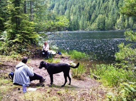
Time for lunch with the dogs. We were all hungry after the hike up.
You need to get to Gambier Island before you can start the hike and the easiest way to do this is to catch the little ferry that leaves from Langdale ferry terminal. The cost as of July 2011 is $7.15 each way which includes the 5% fuel surcharge. Click here to see the ferry schedule.
Make sure to take water and food with you. At present there is no store on the Island. The community centre is open for dinner on Friday evenings from 5 - 8 pm, and in the summer they also do breakfast and lunch from 10 am - 2 pm on the weekends. I wouldn't count on it though.
Access to the starting point is straight forward:
- Go to the Langdale ferry terminal and park. Cost shouldn't be more than $2 or $3.
- Head down the foot passenger walkway. The ferry to Gambier is left of where the big ferry docks.
The image below is interactive. It's a Google Earth gadget that embeds the image of the trail route. You can zoom in and out of it with the zoom bar on the right. You can also use the slider bar to move through the route. It's pretty cool.

Click on the map above to open a higher resolution pdf version.
- Once you reach New Brighton, head off the dock and go straight up the road (don't turn left).
- Follow this dirt road up past the parked vehicles and go left at the closed Gambier Island store (its for sale right now July 2011).
- You will stay on this road for quite some distance, past the community centre on your left and up the hill past a farm called "The Farm".
- Keep climbing this road for the next two kilometres through what some describe as a new subdivision, but honestly it's pretty hard to tell that's what it is. You will recognize you are here by the change in the road base - it changes to larger flat rocks for a short distance.
- The road will level out just before you reach an intersection. At this intersection, behind some young alder trees, you will see a wooden sign that says "The Lake".
- Go left at this intersection. The road will go down for a bit. Stay left at the next intersection. Apparently there is a dark green marker high up on a tree here, but I didn't see it.
- The forest opens up to a clear cut area and the road drops down again to another fork where you again stay left.
- Cross the bridge over Mannion Creek. You will come to a road off to the right which is marked with ribbons. Ignore this and continue to the next right which is well marked and leads to Mount Liddell and Gambier lake.
- The route follows an old logging road that gets worse and worse as you go along. Keep an eye out for the green markers. They will lead you on to the lake.
- You will come to one more intersection that forks off to the left to Mount Liddell. Stay right here to Gambier Lake.
- Keep climbing past a small lake on the left. The trail flattens out for awhile and then descends for almost a kilometre to Gambier Lake. The descent is, at times, quite rough and rocky. Look for the green markers as you go and they'll keep you on track.

Click here to return from Gambier Lake to Bikes & Hikes.
Click here to return from Gambier Lake to the Sunshine Coast Trails Home page.
Enjoy this page? Would you like to link to it? Here's how:
Would you prefer to share this page with others by linking to it?
- Click on the HTML link code below.
- Copy and paste it, adding a note of your own, into your blog, a Web page, forums, a blog comment,
your Facebook account, or anywhere that someone would find this page valuable.


