Homesite Creek Loop
The Homesite Creek area is located between the north end of Redrooffs Rd. and Secret Cove. This route is one I've been riding and hiking for over 15 years. I really love this part of the Coast. Part of the route has also been incorporated into the Suncoaster Trail.
I chose to ride the route starting out by following the Suncoaster Trail. When ridden in this direction, most of the uphill is done on the logging roads and once it is done, the rest of the ride is pretty much downhill. However, feel free to ride it whichever way you like. Riding, the Homesite Creek Loop will take approx. 1 to 1.5 hours - depending how slow you take the uphill. Hiking will likely take between 1.5 and 2 hours. The total distance of this loop is approx. 9 kilometres. The route itself covers logging roads and dirt tracks. I would classify this as mostly easy with a bit of intermediate terrain here and there. This route is also suitable for ATV's.

Access to this route: - Take Hwy. 101 approx. 13 km north towards Madeira Park from Sechelt to Homesite Creek Forest Service Road Br. 01.
- Turn right onto the road and park over on the left where the road is wide enough to accommodate 2 or 3 cars.
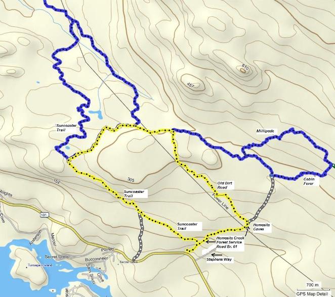
The route is highlighted in yellow on the map below.
Click on the map to open a higher resolution pdf version.

- The first part of this route is simple - just follow the Suncoaster Trail signs - but just in case take the second road on the left.
- Stay on this road til it ends. Turn right here.
- Follow along this road and don't take any of the roads that branch off to the right and left.
- After about a kilometre the road enters into the forest. Still stay on this road.
- You will come to a point where the Suncoaster Trail heads off to the left - don't take it (unless you want to of course). You are going to continue on this road until it comes out onto a main logging road.
- Turn right here and follow along, under the powerlines and up a moderate hill. There will be a couple of roads/tracks that branch off to the right, but you are taking the first big track to the right (about 3/4 km).
- This track parallels the powerline more or less, all the way down to the forest service road you started on down at the beginning of the route.
- Turn right and follow the road back down to your car (about 2 km).
Here's the same route shown using Google Earth viewer.
|


