Langdale to Sprockids Hiking & Biking Route
The Langdale to Sprockids Park route is a great hiking and biking route, and if you are stuck waiting for a ferry, it is conveniently close to the terminal. It is an uphill climb to get to Sprockids, but once there you know it will be all downhill on the way back. If you've got your dogs with you, just remember to keep them leashed until you hit the trails and keep them close in Sprockids to avoid problems with bikes. Here's how to get to the trail head: - At the lights at the highway entrance to the terminal turn right if you are coming from the terminal and left if you are coming down the bypass.
- Take the first left up Wharf Rd. and follow it to the end. If you have your car park here.
- The trail enters straight in from the end of the road.
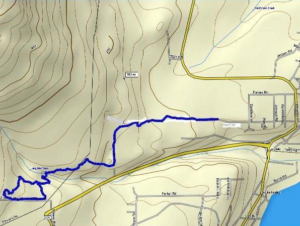
The image below is actually interactive. It is a Google Earth gadget that embeds the image of the trail route that you can zoom in and out of with the zoom bar on the right. You can also use the slider bar to back up through the route. It's pretty cool. You can close the bubble to get it out of your way if you like.
Click on the map below to open a higher resolution pdf version.

Langdale to Sprockids route using Mapsource. Please note Mapsource is not always accurate. It shows the trail entering Sprockids Park just left of Stewart Rd. and it should be to the right.
- Follow the trail straight up for about 2 km. You will see trails off to the right and left. Only take these if you don't want to go all the way to the top. The trail you come to on the left takes you over to private property, but the one you come to on the right takes you over behind the school and out to the other side of Langdale.
- You will pass a little pond on the left after about 10 minutes or so. This is not a great place to let the dogs have a swim or drink.
According to a local in the area "the pond is in a quarry that was used at the time the Bypass was built. The rocks in that quarry contain arsenic minerals. Some of the arsenic is bound to get into the pond, especially when water has had a chance to sit there for a while. I doubt that a dog will be harmed by splashing around in it, or even lapping up some of the water, occasionally. Since we go by there almost every day, we don't let our dog go into or drink the water. Frequent exposure probably wouldn't be a good idea." There will be other, better places to let the dogs drink, etc. further on. - Keep on the trail until you come out to the powerlines. Go left if you want to carry on to Sprockids or go right if you want to follow the powerline road.
- After a short distance you will head back into the forest. Follow the trail down to Langdale creek and cross the bridge.
- The trail after the bridge is a steep climb up, but not too long. Its name is Lunge. Once you get to the top, follow the trail to the right.
- You will come out to a main trail with a tree marked with a blue diamond and yellow diamond. Follow either up into the park. Blue will come back out onto yellow anyway.
- The route pictured takes you into the bike skills area and back down to the main trail back into the park, but you will see other choices and what you do is really up to you.
- If you decide to stick to my route, take the first trail to the left over to the skills/trials area.
- Cut through this area and out the main access road. You will pass a trail off to the right. This is ankle biter.
- Follow the road down past the gate at the bottom, past the parking area on the other side of Stewart Rd. and back into the park on the first trail on your left - just before the private property sign.
- The tree at the entrance is marked with white, yellow and blue markers. Follow it along til you get to Lunge on your right and then you should be able to retrace your route down to Wharf Rd.
Click here to return from Langdale to the Bikes & Hikes page.
Click here to return from Langdale to the Sunshine Coast Trails Home page.
Enjoy this page? Would you like to link to it? Here's how:
Would you prefer to share this page with others by linking to it?
- Click on the HTML link code below.
- Copy and paste it, adding a note of your own, into your blog, a Web page, forums, a blog comment,
your Facebook account, or anywhere that someone would find this page valuable.
|

