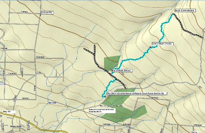
Mach Chicken Hiking & Biking Route
Mach Chicken is an extremely popular downhill trail located in Roberts Creek. It was the featured event on day two of the Sunshine Coaster Mountain Bike Race on the weekend of May 1 & 2, 2011. If you hike it like I did, be sure to keep an eye out for the riders as they come down the trails at a very high speed and cannot stop quickly.
Here are the directions to get here:
- If you are coming from Gibsons, travel approx. 10 km to Roberts Creek Forest Service Rd. (500 m before Cliff Gilker Park).
- Turn right on the forest service road and travel about 1.9 km up, past the powerlines to a pull-out on the left where 2 or 3 cars can park.
If you are riding, I would park here and definitely continue up the forest service road so you can ride the trails down (or work out a shuttle with a friend). If you are hiking you could do this hike either direction you like.
The image below is actually interactive. It is a Google Earth gadget that embeds the image of the trail route that you can zoom in and out of with the zoom bar on the right. You can also use the slider bar to back up through the route. It's pretty cool.

- Head up the road and turn left on the third spur road you come to at 4.6 km from the highway, 2.7 km from where you parked.
- Turn left again at the second spur you come to at the 6.2 km mark. The first one you see is smaller, called Dude's Bypass and connects to Janet's Jungle. Just before you get to the second spur you will also see a trail off to the left. Don't take this one either!
- Follow this spur to the end - just over a kilometre and past the big rock. Guy's Gulch starts on the left at the end of the road.
- Guy's Gulch is about a kilometre long and goes off to the left just before you get to Up'n'Over. You want to keep slightly right and on to Up'n'Over and directly to the start of Mach Chicken.
Mach Chicken has three parts.
- This first part of the trail is rated Intermediate and is the easiest piece. It comes out onto a spur road and banks to the left.
- Go down this road a very short way and back into the second part of the trail on your left.
- This part of the trail is rated Extreme and is very steep in places with several banked turns.
- You will come out onto another spur road and cross into the last section of the trail. Again it is rated Extreme with very steep and slippery sections.
- Once again you will pop out to another spur road (although this is a main one so be careful to not just shoot out onto the road as there is traffic on this one).
- Turn left and travel a short distance to the entrance of the last trail(no sign here)on the right. This trail is supposedly called Brodie, but the sign at the end where you parked your car says The Circle.
- Follow the trail for about a kilometre until it comes to a T. Turn left and back to your car, which should be parked here at the end of the trail.
Click here to return from Mach Chicken to the Bikes & Hikes page.
Click here to return from Mach Chicken to the Sunshine Coast Trails Home Page.
Enjoy this page? Would you like to link to it? Here's how:
Would you prefer to share this page with others by linking to it?
- Click on the HTML link code below.
- Copy and paste it, adding a note of your own, into your blog, a Web page, forums, a blog comment,
your Facebook account, or anywhere that someone would find this page valuable.
|

