Mount Elphinstone Summit Trail Route
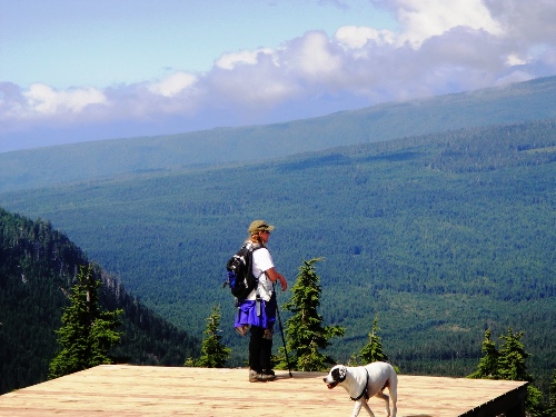
Mount Elphinstone is one of the highest peaks (1260m or 4137 ft) to hike to on the lower Sunshine Coast area. The actual Summit trail to the top is fairly new and I believe was only completed in 2010. The hike up is through second growth forest and there are no views until about 3/4 of the way up. Once to the top the views are expansive and you can see for miles and miles - all the way to Vancouver on a clear day.
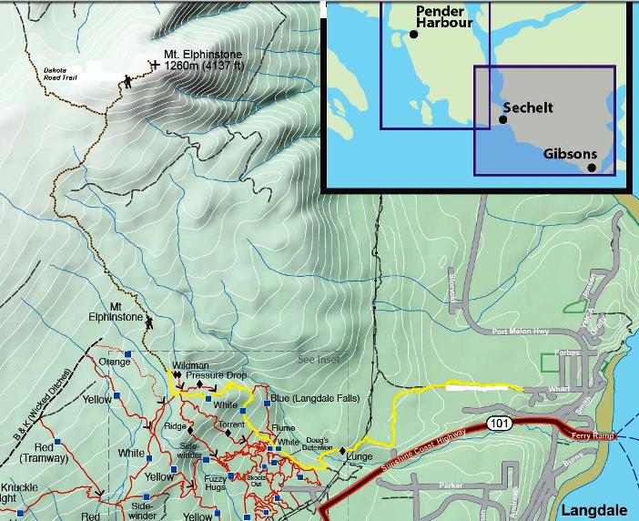
There are a number of routes to get to the Mt. Elphinstone Summit trail. This one is probably the most direct route and starts in Langdale. However, it is also the most physically challenging as you are starting at sea level which means a total elevation gain of about 4100 feet.
I specifically showed this one with instructions for those who arrive by ferry and wish to walk off to do the hike. For those who live in the area you can access the White trail from the lower end of Sprockids.
1.After disembarking the ferry turn right at the light. This is the Port Mellon Hwy.
2. Walk a short distance and take a left on Wharf Rd. Go to the end and you will see a trail continues on into the bush.
3. Follow this trail. You will see trails that go off to the right and left, but you stay on the main one. You will pass a small rock quarry with pond on the left. If you have dogs don't let them drink this water as I understand there is arsenic that has leached into this water.
4. Keep following this trail and when you come to the power lines you will be going to the left still following the trail which parallels the power line for a short way.
5. After another five minutes or so you will come to a bridge over Langdale Creek. Once you reach the other side you are into the Sprockids bike park and the trail is officially called Lunge.
6. Follow Lunge for a few minutes up hill until it comes to an intersection. You are going right here and will follow the White trail until you reach the Elphinstone Summit trail. The time to reach the Summit trail will likely be between 20-40 minutes depending on your speed.
7. When you start on the White trail you will notice it is marked with multiple coloured diamonds, but as you go you will eventually be left with the just the white.
8.If you look at the map you will see that you actually come to a trail called Pressure Drop and then another called Wildman. I would bypass these trails and take the next trail to the right which is marked with a yellow marker and a sign that says Mt. Elphinstone Summit trail.
9.The first half of Mount Elphinstone Summit trail is a moderate climb. You will hear Langdale Creek down below for quite a way and will eventually cross it again at about the half way mark (you crossed it earlier on just before entering Sprockids Bike Park).
10. 10 or 15 minutes past the creek crossing you will come to a viewpoint. This is about 3100 feet. 1000 feet to go!
11. There is a stretch of the trail that goes in and out of boggy, wet terrain. Considering I was hiking it in August, I think earlier in the year this would be a very, very wet slog. The mosquitoes and little black flies were bad.
12. A little further on you will come to an intersection with a trail going off to the left. It is marked To Dakota Creek Roads. Note: This trail takes you out to an old, deactivated logging road that joins up with another old road and if you stay left you eventually come out to a different branch of B & K. It is about a 1/2 hour to an hour to hike out to the B & K. You would be able to get fairly close to the trail by atv, but not all the way as there are some very deep gullies and the road is partially washed out in places. I did notice some tire marks to within about a 10 minute walk to where the trail comes out to the road. The trail is marked on the road on some logs with a sign that says To Mount Elphinstone trails and this trail is marked with red markers. This has actually become my favourite route in and out.
13. Anyway, at this junction keep right if you want to get to the top of the mountain. DO NOT GO LEFT. This part of the hike is fairly steep, but only takes about 15 minutes or so.
14. You will come to a bluff area with views, but the trail continues on to another bluff area marked with a flag. This is still not the top. Keep following the trail until you get to the tippy top of the mountain where you will see a cell tower and wooden helicopter pad.

Alternate Route to Mt. Elphinstone Summit Trail
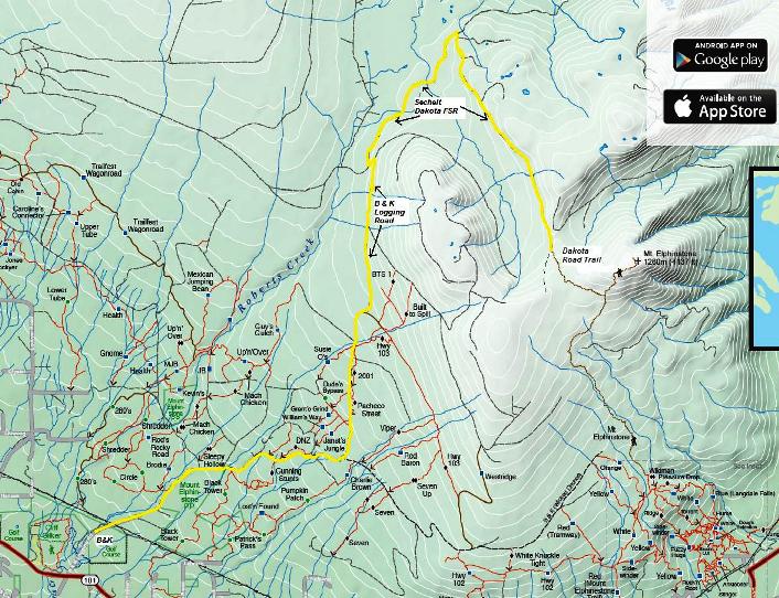
The map below shows an alternate route (in yellow) to Mt. Elphinstone. It is shorter than the previous route and less than half the elevation gain. It is also very simple:
- Take Hwy. 101 to the B & K Logging Road.
- Follow the B & K staying left at Branch 6 and going approx. 8 or 9 kms.
- Turn right on the Sechelt Dakota Forest Service Road (just after the corner and down the hill.)
- Follow this road for a couple kms and take the first logging road on the right that you come to.
- Stay on this road all the way to the sign for Mt. Elphinstone trails - about 45 - 60 minutes hiking.
- This trail climbs quite steeply for five or ten minutes and then crosses a meadow/marsh area. You will come to the main Mt. Elphinstone Summit trail and turn left to head up to the top. About another 15 - 30 minutes.
Click here to return from Mount Elphinstone to the Hikes and Bikes page.
Click here to return from Mount Elphinstone to the Sunshine Coast Home page.


New! Comments
I began this site as a labour of love and in response to what I believed was a need to have one comprehensive website with detailed information about all trails on the Sunshine Coast.So here it is several months later and I've had so much fun hiking, biking and gpsing nearly every trail on the Sunshine Coast. Along the way the site has gained some loyal followers and we would love to know your thoughts about this page, site and/or the Sunshine Coast...
So if you have a moment (and a Facebook account OR Yahoo, AOL, Hotmail) please leave a comment in the box below.